The population and infrastructure on the Adelaide Plains is growing fast. We have strategies and plans in place to make sure our growth is sustainable and balanced to maintain our enviable lifestyle and remarkable landscapes.
We are the fastest growing council in SA, in terms of percentage of population increase year on year. It is anticipated around 400 new residents every year will call Adelaide Plains home. Growth projections in the Greater Adelaide Regional Plan estimate Adelaide Plains’ population to be 19,955 in 2041.
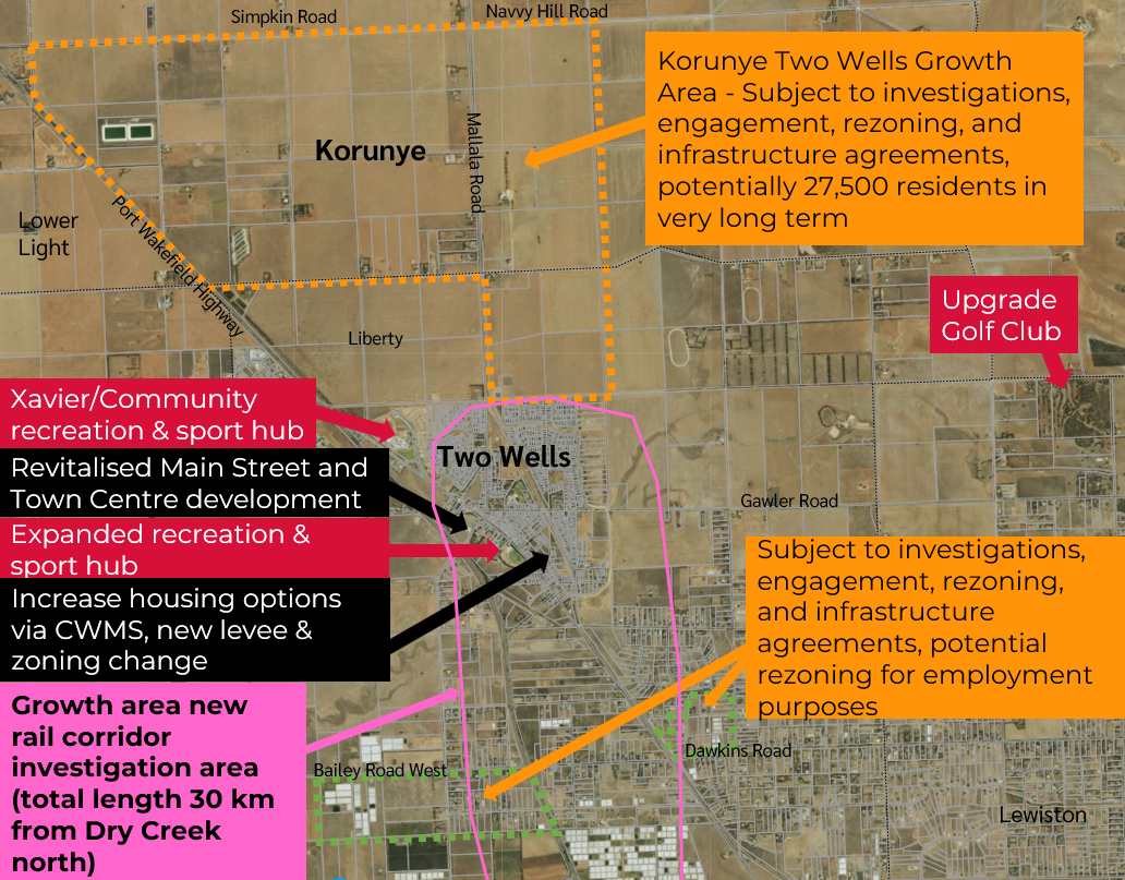
Two Wells is experiencing 80% of our estimated population growth.
Read Adelaide Plains Growth Projections
Greater Adelaide Regional Plan
The Greater Adelaide Regional Plan is the State Government’s plan for how the region might grow over the next 15 to 30 years. This Plan significantly influences Council’s own growth planning and Council’s direct role in service and infrastructure provision.
We provided feedback to the Greater Adelaide Regional Plan consultation in 2023. Greater Adelaide Regional Plan investigations and engagement will be occurring over 2024 to 2026.
Over 2025–2026, our Growth Strategy will be updated to reflect the actions achieved, the 2025 Greater Adelaide Regional Plan and to include locations to advocate for the orderly lifting of the Environment and Food Production Area. This is an action identified in our strategic plan.
 Submission to draft Greater Adelaide Regional Plan - November 2024 (PDF File, 1011.9 KB)
Submission supporting documents to Draft Greater Adelaide Regional Plan - November 2024 (PDF File, 16.5 MB)
Summary Greater Adelaide Regional Plan and Adelaide Plains, Mid 2025 (PDF File, 1.3 MB)
Read about the Greater Adelaide Regional Plan
Note: Population numbers and forecasts based on data from the Australian Bureau of Statistics, Department of Planning, Transport and Infrastructure and forecast about potential future land development.
Rezoning/Code Amendments
The Planning and Design Code (the Code) is a statutory instrument under the Planning, Development and Infrastructure Act 2016 which guides development assessment decision making.
The Code contains the planning rules and policies that guide what can be developed on land. Planning authorities use these planning rules to assess development proposals.
A code amendment is a proposal to change the policies, rules, or mapping within the Code.
All code amendments underway in Adelaide Plains are available via the Plan SA website. If there is land you are interested in not on this website, please contact us.
Read about Code Amendments
Open space, recreation and sport planning
We have developed an Open Space Plan to guide the provision, development and management of open spaces for the next 10 years and more. The Plan relates to open space that is owned or managed by Council and includes parks, sports grounds and natural areas. Undertaking a master plan for the Two Wells Recreation and Sport Precinct commenced in 2023. Work looking at needed sport, recreation and open spaces over the next 30 years as our community grows is underway.
Open Space Plan - Background - 2016 (PDF File, 2.2 MB)
Open Space Plan - Directions - 2016 (PDF File, 3.0 MB)
Dublin Oval Precinct 2023 - 2032 Concept Plan (PDF File, 700.4 KB)
Xavier College Community Use Background 2025 (PDF File, 1.8 MB)
Salt Creek Middle Beach Options 2026 (PDF File, 1.0 MB)
As a growing and changing region, investigating and planning for suitable community facilities in the context of many community, sporting and faith based facilities is important to help foster community connection, health and wellbeing.
Two Wells Community Facilities Advice 2026 (PDF File, 554.5 KB)
Coastal planning
The management and development of 47 kilometres of coastline presents an ongoing challenge in balancing the competing demands of the coast as a valuable environmental, social, cultural and economic resource. Coastal projects and studies are undertaken to protect the coastal environment and promote appropriate activities as our population increases.
Coastal settlements adaptation studies
We commissioned the University of South Australia to undertake a Coastal Settlements Adaptation Study in 2013. The study was to evaluate how rising sea levels will impact the settlements of Parham, Webb Beach, Thompson Beach and Middle Beach and to propose adaptation strategies to cope with changes in sea level and sea flooding. An updated coastal adaptation study is intended to be prepared.
Coastal Settlements Adaptations Study: State of Play Report (2013)
Coastal Settlements Adaptation Study- State of Play - Appendices (PDF File, 3.6 MB)
Coastal Settlements Adaptation Study- State of Play - Final Report (PDF File, 5.5 MB)
Coastal Settlements Adaptation Study- State of Play Report- Final Maps (PDF File, 4.7 MB)
Coastal Settlements Adaptations Study: Framework Reports (2014)
Middle Beach Framework Report (PDF File, 1.8 MB)
Parham Framework Report (PDF File, 1.8 MB)
Thompson Beach Framework Report (PDF File, 1.2 MB)
Webb Beach Framework Report (PDF File, 809.7 KB)
Stormwater and flood management
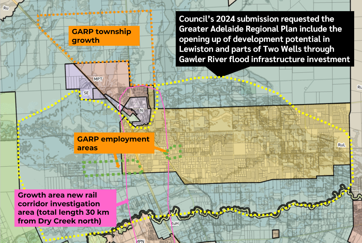
Areas within Adelaide Plains are subject to flooding from a variety of sources including the Light River, the Gawler River and from localised urban surface water runoff. Flooding from Salt Creek can also occur due to the Light River and the Gawler River.
Floodplain mapping for the Gawler River and the Light River has been prepared by Australian Water Environments to help guide development decisions, infrastructure works and mitigation measures in flood-prone areas.
Gawler River Floodplain Mapping - 1 in 100 Year ARI Flood Inundation Map (PDF File, 1.3 MB)
Gawler River Floodplain Mapping - 1 in 100 Year ARI Flood Hazard Map (PDF File, 1.2 MB)
Gawler and Light River Flood Mapping - 1 in 100 Year ARI (PDF File, 5.3 MB)
Council has prepared a Two Wells Stormwater Management Plan to help plan future infrastructure upgrades.
Two Wells Stormwater Management Plan (PDF File, 7.6 MB)
Primary production, horticulture and rural lands
The Northern Food Bowl
The Greater Adelaide Regional Plan provides a strong commitment to growing the State’s food industry, making the best use of water resources and protecting areas of valuable primary production land.
As part of the Northern Adelaide Plains ‘food bowl’, Adelaide Plains is an area of major primary production and horticulture significance which is vital for the economic and social future of Adelaide Plains and the wider region.
Studies have been undertaken to help plan for the long-term sustainability of broadacre farming and the horticulture industry in the region.
Allied Food Industries Land Supply Study (PDF File, 3.3 MB)
Mallala Broadacre Farming Study (PDF File, 2.4 MB)
Northern Adelaide Irrigation Scheme - Market Proving Study (PDF File, 1.6 MB)
Virginia and Northern Adelaide Plains Horticulture Study - Framework Report (PDF File, 3.3 MB)
Virginia and Northern Adelaide Plains Horticulture Study - State of Play Report (PDF File, 12.9 MB)
To secure future development and sustainability of Council’s food production areas were undertaken in 2017 and 2018. This was introduced concurrently with the Northern Adelaide Irrigation Scheme commencing.
Equine sector
A range of horse based businesses and clubs call Adelaide Plains home. Many residents – in particular in Rural Living areas and through the Animal Husbandry Area in Lewistown – choose to live in Adelaide Plains as they can have horses.
Recognising this significant sector in Adelaide Plains, after investigations and consultation, an Equine Strategy and Background Paper was adopted in 2023.
Equine Strategy (PDF File, 266.1 KB)
Equine Background Paper (PDF File, 2.5 MB)
Equine Strategy Consultation Report (PDF File, 304.4 KB)
Last updated 21 September 2026

![Dublin showing areas of potential future growth. There are zones for township, rural living, rural, conservation and specialized employment.]](https://www.apc.sa.gov.au/__data/assets/image/0025/1706065/Dublin-Growth-Planning-Map.png "Potential future potential growth areas at Dublin.")
![A map of the township of Mallala, highlighting areas of potential growth. There are zones for neighbourhood, rural living, township activity, employment, recreation, and rural.]](https://www.apc.sa.gov.au/__data/assets/image/0023/1706072/Mallala-Growth-Planning-Map.png "Potential residential growth in the long term to the north and east of Mallala being investigated.")